Weather@Cornwall NY

Welcome to Weather@Cornwall NY

The Greater Cornwall communities' official source for real-time localized weather conditions, radar, live feeds, forecasts, alerts and events. Learn more about the Cornwall Office of Emergency Management Environmental Intelligence Programs and Stay Informed!

WX Alerts
Stay in the know with WX Alerts
Let's get started - Signup Now!

Social WX Wall
Be updated with Social WX Wall
Let's visit Social WX Wall

Current Forecasts
Access Weather Conditions
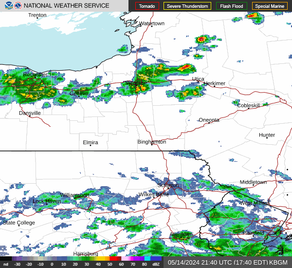
Let's check current conditions

Live Radar
Check Cornwall Live Radar
Let's check radar

Air Quality
Check Cornwall Air Quality
Let's check air quality

Current Flood Risks
Check Cornwall Flood Risk
Let's check flood risks

Live Feeds
View WX Station Live Feeds
Let's visit camera feeds

Report WX Damage
Submit Photos and Videos
Report via OEM's RavenGIS™

Cornwall OEM
Plan. Prepare. Be Informed.
Let's visit Ready Cornwall!

Greater Cornwall WX Alerts

Stay in the know with Greater Cornwall NY Weather Alerts! Active will be displayed here. Ready to receive alerts? Sign up now!
Current watches, warnings, and advisories for Orange (NYZ067) NY
Last Update: Thu Oct 30 2025 14:46:59 EDT
THERE IS 1 ACTIVE ALERT!

wx.cornwallny.gov
On FB @cornwalloem

warning WIND ADVISORY IN EFFECT FROM NOON FRIDAY TO MIDNIGHT EDT FRIDAY NIGHT
Wind Advisory issued October 30 at 2:45PM EDT until November 1 at 12:00AM EDT by NWS Upton NY (Region Impacted: Northern Fairfield; Northern New Haven; Northern Middlesex; Northern New London; Southern Fairfield; Southern New Haven; Southern Middlesex; Southern New London; Western Passaic; Eastern Passaic; Hudson; Western Bergen; Eastern Bergen; Western Essex; Eastern Essex; Western Union; Eastern Union; Orange; Putnam; Rockland; Northern Westchester; Southern Westchester; New York (Manhattan); Bronx; Richmond (Staten Is.); Kings (Brooklyn); Northwest Suffolk; Northeast Suffolk; Southwest Suffolk; Southeast Suffolk; Northern Queens; Northern Nassau; Southern Queens; Southern Nassau)
* WHAT...West winds 20 to 25 mph with gusts 40 to 45 mph expected. * WHERE...Southeast New York, northeast New Jersey, and southern Connecticut. * WHEN...From noon Friday to midnight EDT Friday Night. * IMPACTS...Gusty winds will blow around Halloween decorations and other unsecured objects. Tree limbs could be blown down and a few power outages may result.

WX@Cornwall Social WX Wall

Official WX Feeds

Greater Cornwall Latest Radar

Latest Radar Loop : NWS OKX - New York City, NY

Latest Radar Loop NWS Office OKX - New York City, NY

Latest Radar Loop : NWS BGM - Binghamton, NY

Latest Radar Loop NWS Office BGM - Binghamton, NY

Radar Map for the Greater Cornwall Area

Weather Data: N/A
Temperature: N/A
Current Layer: N/A
Timestamp: N/A

Greater Cornwall Latest Air Quality

Air Quality Map for the Greater Cornwall Area

Air Quality Index: N/A
Health Recommendation: N/A

Greater Cornwall Latest Flood Risk

Flood Risk Map for the Greater Cornwall Area

Flood Risk Level: N/A

Greater Cornwall Weather Conditions and Forecasts

Current Conditions for Greater Cornwall

Current Conditions - Cornwall-on-Hudson

Overnight

Rain showers likely before 3am. Mostly cloudy. Low around 50, with temperatures rising to around 53 overnight. Southwest wind around 6 mph. Chance of precipitation is 60%.
Rain Showers Likely
50 °F : 6 mph SW
Elevation: 75ft

Current Conditions - Cornwall / Firthcliffe

Overnight

Rain showers likely before 3am. Mostly cloudy. Low around 49, with temperatures rising to around 52 overnight. Southwest wind 6 to 10 mph, with gusts as high as 21 mph. Chance of precipitation is 60%.
Rain Showers Likely
49 °F : 6 to 10 mph SW
Elevation: 331.02ft

Current Conditions - Mountainville

Overnight

Rain showers likely before 3am. Mostly cloudy. Low around 49, with temperatures rising to around 53 overnight. Southwest wind 6 to 12 mph, with gusts as high as 23 mph. Chance of precipitation is 60%.
Rain Showers Likely
49 °F : 6 to 12 mph SW
Elevation: 299.01ft

12 Hour Zone Forecast Orange County (NYZ067)

Overnight
A chance of rain showers before 3am. Mostly cloudy. Low around 47, with temperatures rising to around 52 overnight. West wind 6 to 14 mph, with gusts as high as 26 mph. Chance of precipitation is 40%.
Chance Rain Showers
47 °F : 6 to 14 mph W
Friday
Partly sunny. High near 51, with temperatures falling to around 49 in the afternoon. West wind 13 to 18 mph, with gusts as high as 41 mph.
Partly Sunny
51 °F : 13 to 18 mph W